This trail is part of the mountain race known as the Trail del Salto, which takes place in the town at the beginning of the year. The Trail del Salto has a distance of 11.130 m and is of moderate technical difficulty.
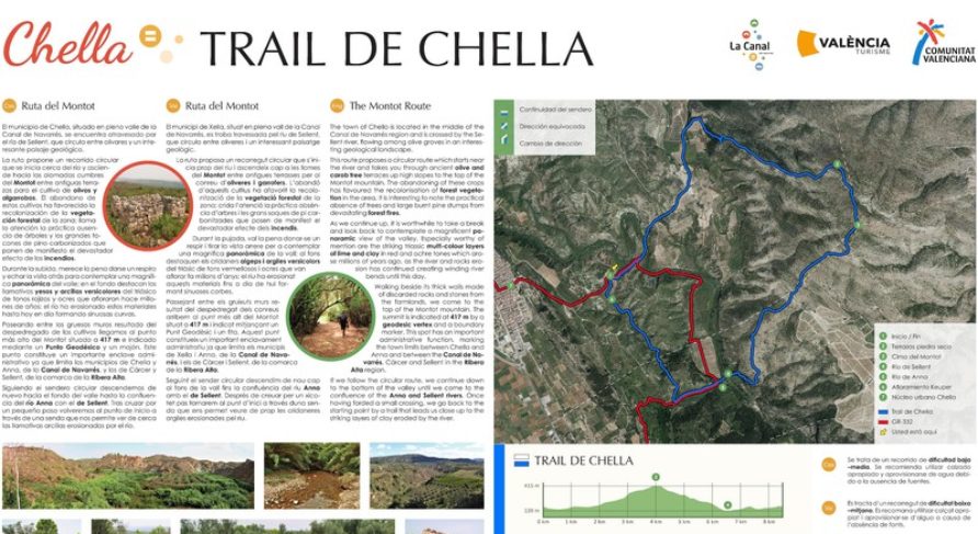
The highest point of Montot is reached by previously crossing the ravine of the Sellent river through the area of Fuente de la Parra, with its picturesque pool of water and a small waterfall. From this point, the ascent to the top of Montot begins, the highest point of the route (417 m above sea level, Km 9.5). It is a privileged viewpoint of the municipal area and part of the region. Next, the trail runs through the set of hills of Las Rochas, where the enclosed river forms the well-known meanders of Vuelta de Roses. The return to the town crosses, in its final stretch, the spectacular waterfall that gives its name to the trail, emblem of the town and one of the most beautiful spots in the area.
This website uses cookies so that we can provide you with the best user experience possible. Cookie information is stored in your browser and performs functions such as recognising you when you return to our website and helping our team to understand which sections of the website you find most interesting and useful.
Strictly Necessary Cookies
Strictly Necessary Cookie should be enabled at all times so that we can save your preferences for cookie settings.
If you disable this cookie, we will not be able to save your preferences. This means that every time you visit this website you will need to enable or disable cookies again.