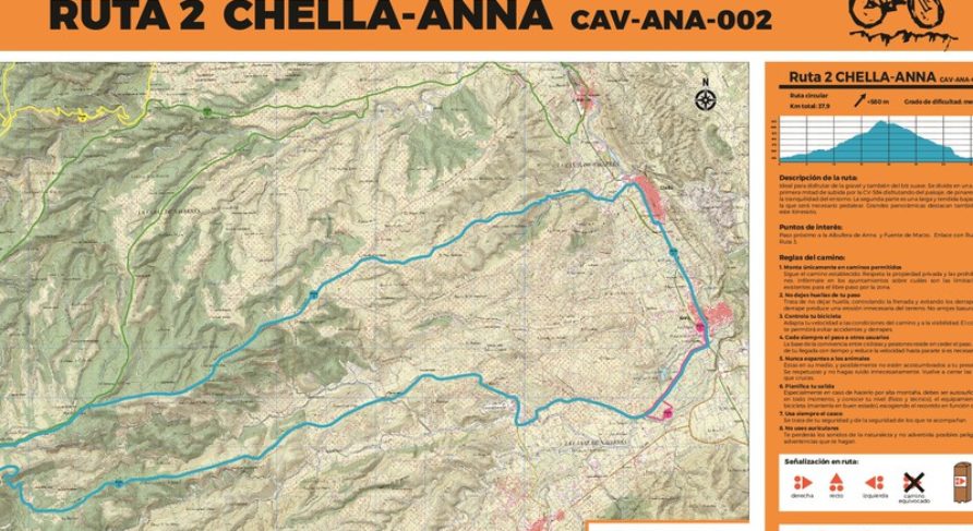
– Start: Anna End: Anna
– Circular: Yes Direction: Clockwise. Can be done counterclockwise: Yes
– Technical path or trail km: 0
– Track or path km: 7.1 (19%)
– Asphalt path km: 14 (37%)
– Mountain road km: 13.7 (37%)
– Main road km: 0.5 (1%)
– Bike lane km: 2.4 (6%)
– Total km: 37.9 Positive elevation: +580
– Route ratings from 0 to 5 stars:
MTB: * Gravel: ****
– Difficulty (low, medium, or high)
Technical: low / Physical: low-medium.
– Points of interest: Next to Albufera at km 1.7 and Fuente de Marzo at km 2.2. Link with 3MILES at km 18.9.
Brief description of the route:
Ideal for enjoying gravel and also gentle MTB. It is divided into a clear first half of ascent along the CV-584 enjoying the landscape, pine forests, and the tranquility of the surroundings. The second part is a long and gentle descent where pedaling will be necessary. Great panoramic views.
This route can be used to link with the 3MILES after leaving Anna.
Sehr angenehme Route, 23 km ‚Spaziergang‘, ideal für Gravel und sanftes Mountainbiken. Ohne große Höhenunterschiede, gut gepflegte Pisten, asphaltierte Wege,
Diese Website verwendet Cookies, damit wir dir die bestmögliche Benutzererfahrung bieten können. Cookie-Informationen werden in deinem Browser gespeichert und führen Funktionen aus, wie das Wiedererkennen von dir, wenn du auf unsere Website zurückkehrst, und hilft unserem Team zu verstehen, welche Abschnitte der Website für dich am interessantesten und nützlichsten sind.
Unbedingt notwendige Cookies
Unbedingt notwendige Cookies sollten jederzeit aktiviert sein, damit wir deine Einstellungen für die Cookie-Einstellungen speichern können.
Wenn du diesen Cookie deaktivierst, können wir die Einstellungen nicht speichern. Dies bedeutet, dass du jedes Mal, wenn du diese Website besuchst, die Cookies erneut aktivieren oder deaktivieren musst.